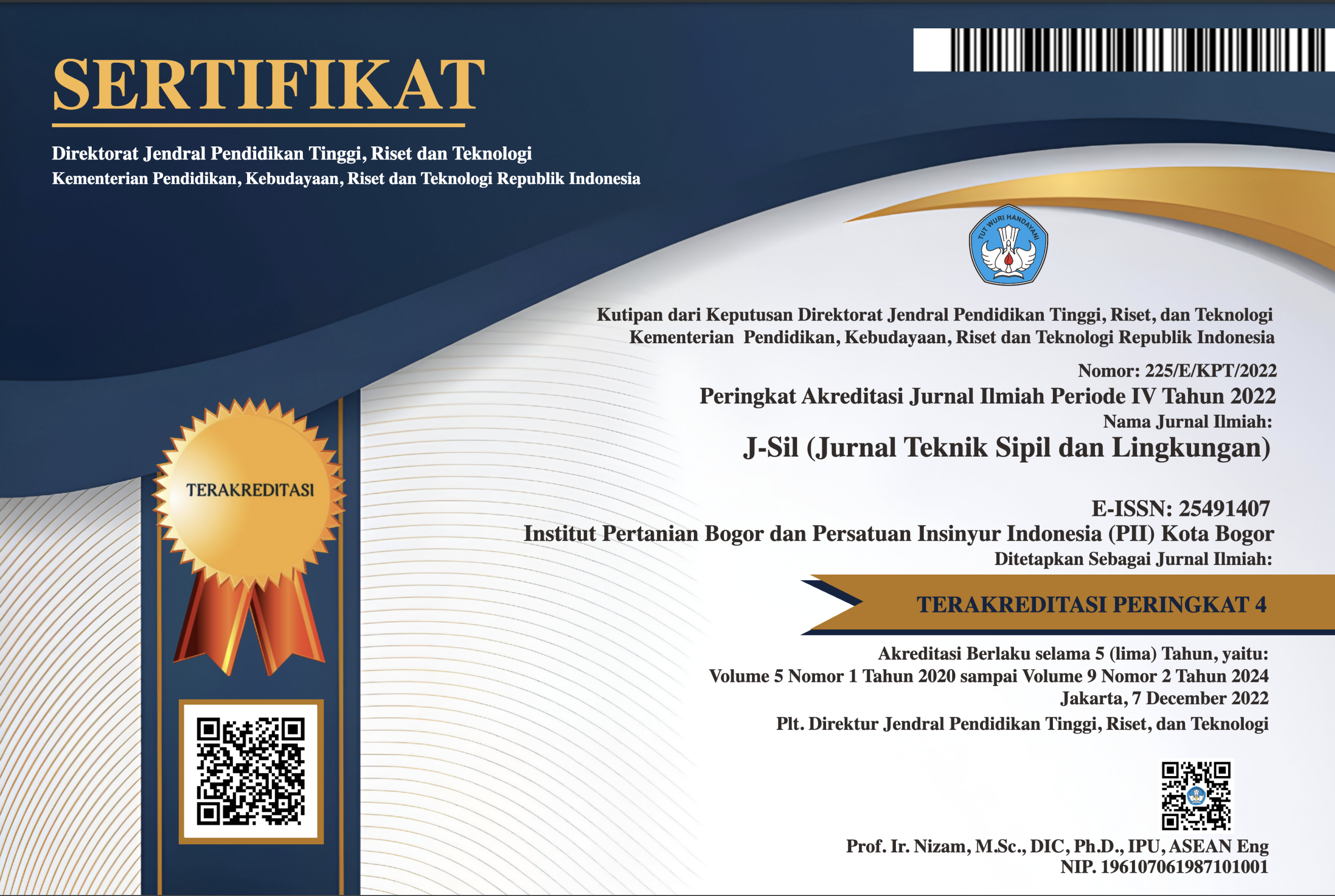
Evaluasi Geometri Jalan Menggunakan Uav Dengan Aplikasi Agisoft Photoscanner Pada Jalan Meranti Kampus IPB Dramaga
Abstract
There are various road construction projects in Indonesia, but most of these projects still use conventional methods in evaluating road geometry. This study aims to evaluate the geometry of the road using UAV and analyze the accuracy and accuracy of photogrammetry in the evaluation of road geometry. This research took place at Dramaga's IPB Campus on Meranti street and was conducted from April to July 2019. From a series of processes that have been carried out it can produce accuracy of measuring 97,243% and 98,296% across the road for orthophoto results without and with coordinate correction and using GCP. For accuracy in this study obtained a value of 0.858 m so that it can be concluded that the data processing map is included in the class 3 horizontal accuracy. The horizontal alignment parameters analyzed in this study are bend angles, turn radius, and turn length, there are two curves analyzed. For the value of each parameter each turn successively for data without coordinate correction and elevation is 149 °; 90 °; 40.61 m; 53.75 m; 23.39 m; 90.71 m. The results of horizontal alignment analysis for data with coordinate correction are 150 °; 88 °; 30.81 m; 49.34 m; 21.39 m; 89.3 m. The vertical alignment analyzed in this study has two parameters, namely vertical curvature and slope. The value of the analysis results for the two parameters of the two points for results with correction and without correction of coordinates are 16.08%, 17.22%, 53 m, 51 m and 6.88%, 3.77%, 53 m, and 51 m .
Downloads
References
Andika SA, Mudjiatko, Bambang S. 2015. Analisis Kapasitas Tampungan Waduk Sungai Paku Kecamatan Kampar Kiri Kabupaten Kampar. JOM FTEKNIK. 2(2): 1-7
Barmawi ME, Mawardi, Hatmoko W. 2007. Penelitian Ketersediaan Air Irigasi di Kota Payakumbuh Dalam Rangka Peningkatan Produksi Padi. Jurnal Sumber daya Air. 3(4): 41-48.
Karnanto, Loebis J. 1980. Perhitungan Curah Hujan Maksimum Metode Gumbel dan Probable Maximum Precipitation. Bandung (ID): Direktorat Penyelidikan Masalah Air.
Laoh GL, Tanudjaja L, Wuisan EM, Tangkudung H. 2013. Perencanaan sistem drainase di kawasan pusat Kota Amurang. Jurnal Sipil Statik. 1(5): 341-349.
Sara AS, Syaifullah MD, Findy R. 2016. Karakteristik Hujan dan Awan Penghasil Curah Hujan Harian Tinggi Berdasarkan Data Micro Rain Radar (Studi Kasus: Wilayah Dramaga, Bogor). Jurnal Sains & Teknologi Modifikasi Cuaca. 17 (1): 27-35
Setiyawan, Vera WA, Lisa AA. 2017. Analisis Ketersediaan Air Dengan Metode F.J Mock Pada Daerah Persawahan Desa Poboya Palu Sulawesi Tengah. Jurnal INFRASTRUKTUR. 7(1): 18-26
Soemarto CD. 1999. Hidrologi Teknik. Jakarta (ID): Erlangga
Sunaryo. 2004. Pengelolaan Sumber Daya Air Konsep dan Penerapannya. Malang (ID): Bayumedia Publishing
Suryo A. 2010. Analisis Penyediaan dan Distiribusi Air Bersih untuk Kampus IPB Dramaga, IPB [skripsi]. Bogor (ID): Institut Pertanian Bogor
Verrina GP, Anugrah DD, Sarino. 2013. Analisa Run Off Pada Sub DAS Lematang Hulu. Jurnal Teknik Sipil dan Lingkungan. 1(1): 22-31
Copyright (c) 2020 Jurnal Teknik Sipil dan Lingkungan

This work is licensed under a Creative Commons Attribution-NonCommercial-NoDerivatives 4.0 International License.
Authors who publish with Jurnal Teknik Sipil dan Lingkungan, JSIL agree to the following terms:
a. Authors retain copyright and grant the journal right of first publication with the work simultaneously licensed under a Creative Commons Attribution License that allows others to share the work with an acknowledgment of the work's authorship and initial publication in this journal.
b. Authors are able to enter into separate, additional contractual arrangements for the non-exclusive distribution of the journal's published version of the work (e.g., post it to an institutional repository or publish it in a book), with an acknowledgment of its initial publication in this journal.
c. Authors are permitted and encouraged to post their work online (e.g., in institutional repositories or on their website) prior to and during the submission process, as it can lead to productive exchanges, as well as earlier and greater citation of published work (See The Effect of Open Access).