Land Suitability and Availability Evaluation for Social Forestry in Pesawaran Regency, Lampung Province

Article Sidebar
Abstract
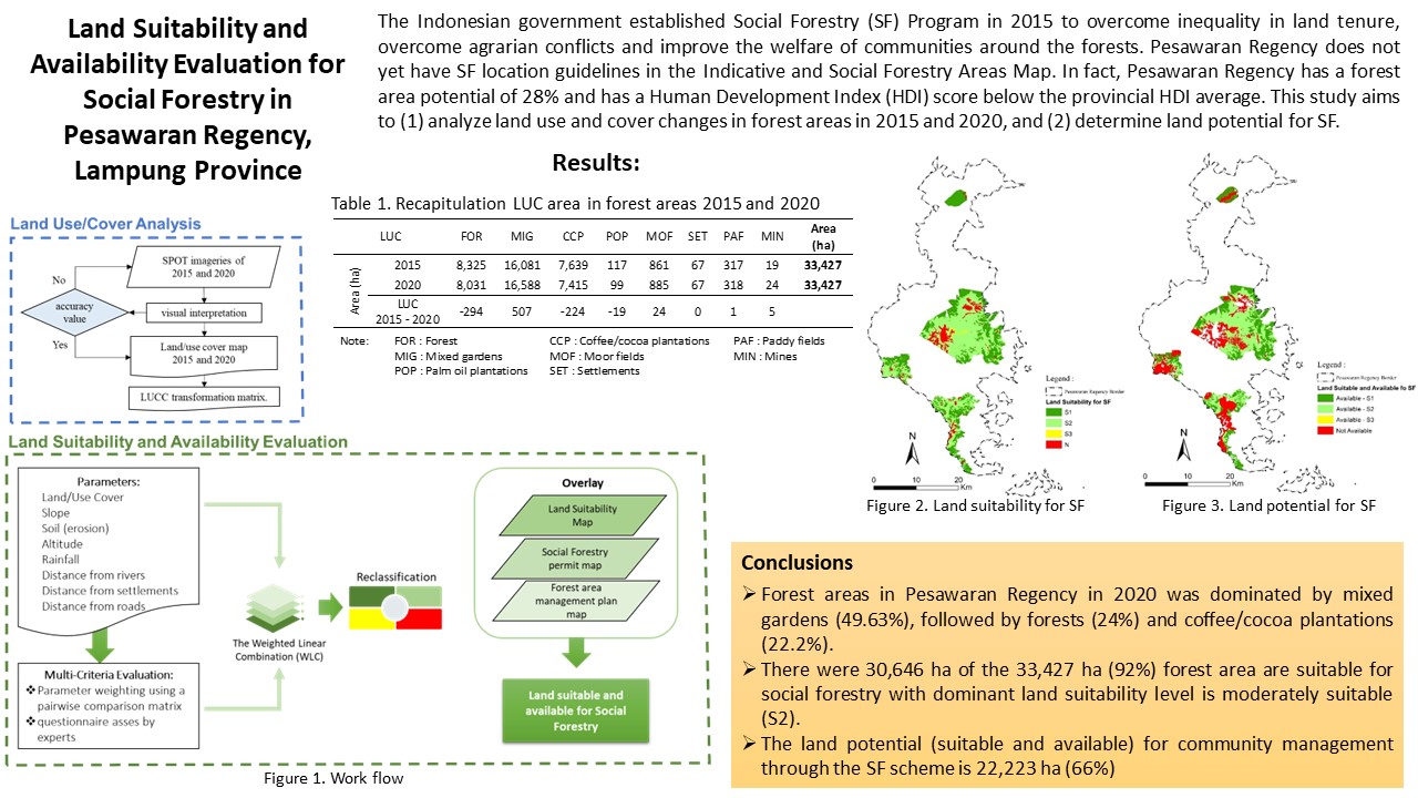
The Indonesian government established Social Forestry (SF) to overcome inequality in land tenure, overcome agrarian conflicts and improve the welfare of communities around the forest. Pesawaran Regency does not yet have SF location guidelines in the Indicative and Social Forestry Areas Map. In fact, Pesawaran Regency has a forest area potential of 28% and has a Human Development Index (HDI) score below the provincial HDI average. This study aims to (1) analyze land use and cover changes in forest areas in 2015 and 2020, and (2) determine land potential for SF. SPOT image is used to analyze land cover with visual interpretation. Land suitability evaluation uses the Multi-Criteria Evaluation (MCE) method based on Geographic Information Systems (GIS). The results show that almost half of the forest area in 2020 is in the form of mixed gardens (49.63%), forests (24%), and coffee/cocoa plantations (22.2%). The direction of change in forest to mixed gardens, coffee/cocoa plantations, and mines. The parameters most influencing the land suitability for SF are land cover, slope, and soil type. Based on land suitability and land availability analysis for SF, it was found that 66% of the research area had potential for SF.
References
Agustini S, Dharmawan AH. 2017. Kontribusi Hutan Nagari Pada Struktur Nafkah dan Ekonomi Pedesaan: Studi Kasus di Padang Pariaman. Sodality: Jurnal Sosiologi Pedesaan. 5(2):138–147.
Agustini S, Dharmawan AH, Putri EIK. 2018. Bentuk Pengelolaan Hutan Nagari Sungai Buluh Kabupaten Padang Pariaman. BHUMI: Jurnal Agraria dan Pertanahan. 3(2):267–278. doi:10.31292/jb.v3i2.129.
Agustiono A, Sitorus SRP, Kartodihardjo H. 2014. Kajian Perubahan Penggunaan Lahan untuk Arahan Penataan Pola Ruang Kawasan Hutan Produksi Gedong Wani, Provinsi Lampung. Majalah Ilmiah Globe. 16(1):59–68.
Anderson JR. 1971. Land-Use Classification Schemes. Photogrammetric Engineering. 37.
BPS. 2020. Identifikasi dan Analisis Desa di sekitar Kawasan Hutan Berbasis Spasial Tahun 2019. Jakarta: BPS Indonesia.
[BPS] Badan Pusat Statistik Provinsi Lampung. 2021. Provinsi Lampung Dalam Angka 2021. Lampung: BPS Provinsi Lampung.
Collins MG, Steiner FR, Rushman MJ. 2001. Land-use suitability analysis in the United States: Historical development and promising technological achievements. Environmental Management. 28(5):611–621. doi:10.1007/s002670010247.
[Ditjen PKTL] Direktorat Jenderal Planologi Kehutanan dan Tata Lingkungan. 2021. Statistik Bidang Planologi Kehutanan dan Tata Lingkungan Tahun 2020. Kementerian Lingkungan Hidup dan Kehutanan.
Eastman JR. 1999. Multi-criteria evaluation and GIS. Geographical information systems. 1(1):493–502.
Faradhana A, Herwanti S, Kaskoyo H. 2019. Peran Hutan Tanaman Rakyat dalam meningkatkan pendapatan di Kesatuan Pengelolaan Hutan Unit XIV Gedong Wani. 2(2):104–111.
Hardjowigeno S, Widiatmaka W. 2007. Evaluasi Lahan dan Perencanaan Tataguna Lahan. Yogyakarta: Gadjah Mada University Press.
Herwirawan FX, Kusmana C, Suhendang E, Widiatmaka W. 2019. Land Suitability for Community Forestry to Poverty Alleviation in the Border Area at Timor Tengah Utara District. Jurnal Pengelolaan Sumberdaya Alam dan Lingkungan (Journal of Natural Resources and Environmental Management). 9(1):29–39. doi:10.29244/jpsl.9.1.29-39.
Jensen JR. 1996. Introductory Digital Image Processing: A Remote Sensing Perspective. Prentice Hall (Prentice Hall series in geographic information science).
Kanel KR, Dahal GR. 2008. Community Forestry Policy and Its Economic Implications: an Experience From Nepal. International Journal of Social Forestry. 1(1):50–60.
[KLHK] Kementerian Lingkungan Hidup dan Kehutanan. 2018. Siaran Pers Nomor: SP.184/HUMAS/PP/HMS.3/04/2018: Komitmen KLHK Untuk Langkah-Langkah Korektif Bidang Kehutanan. http://ppid.menlhk.go.id/siaran_pers/browse/1158#:~:text=Jakarta%2C Kementerian Lingkungan Hidup dan,7%25 dari luas daratan Indonesia.
Köhl M, Magnussen S, Marchetti M. 2006. Sampling Methods, Remote Sensing and GIS Multiresource Forest Inventory. Berlin Heidelberg: Springer-Verlag.
Mweshi GK, Sakyi K. 2020. Application of sampling methods for the research design. Archives of Business Research. 8(11):180–193. doi:10.14738/abr.811.9042.
Nath AJ, Kumar R, Devi NB, Rocky P, Giri K, Sahoo UK, Bajpai RK, Sahu N, Pandey R. 2021. Agroforestry land suitability analysis in the Eastern Indian Himalayan region. Environmental Challenges. 4(July):100199. doi:10.1016/j.envc.2021.100199. https://doi.org/10.1016/j.envc.2021.100199.
[PP] Peraturan Pemerintah Republik Indonesia Nomor 23 Tahun 2021 tentang Penyelenggaraan Kehutanan. 2021.
Rwanga SS, Ndambuki JM. 2017. Accuracy Assessment of Land Use/Land Cover Classification Using Remote Sensing and GIS. International Journal of Geosciences. 08(04):611–622. doi:10.4236/ijg.2017.84033.
Saaty RW. 1987. The analytic hierarchy process-what it is and how it is used. Mathematical Modelling. 9(3–5):161–176. doi:10.1016/0270-0255(87)90473-8.
Sari SP. 2015. Identifikasi Karakteristik dan Pemetaan Tutupan Lahan menggunakan Citra Landsat 8 (OLI) di Kabupaten Pesawaran Provinsi Lampung. [Skripsi]. Bogor: Institut Pertanian Bogor.
Sinatala A. 2006. Konservasi Tanah & Air. Kedua. Bogor: IPB Press.
Sirait DA, Widiatmaka W, Rusdiana O. 2021. Arahan Pengembangan Hutan Rakyat untuk Penanganan Lahan Kritis di Kabupaten Sukabumi, Provinsi Jawa Barat. Tataloka. 23(3):344–353. doi:10.14710/tataloka.23.3.344-353.
Tsegaye NT. 2023. The impact of agroforestry practice on forest conservation and community livelihood improvement: A case of Buno Bedele Zone of west Ethiopia’S Chora district. Environmental and Sustainability Indicators. 17(August 2022). doi:10.1016/j.indic.2023.100229.
Wong GY, Moeliono M, Bong IW, Pham TT, Sahide MAK, Naito D, Brockhaus M. 2020. Social forestry in Southeast Asia: Evolving interests, discourses and the many notions of equity. Geoforum. 117(November):246–258. doi:10.1016/j.geoforum.2020.10.010. https://doi.org/10.1016/j.geoforum.2020.10.010.
Authors

This work is licensed under a Creative Commons Attribution 4.0 International License.
Authors who publish with this journal agree to the following terms:
- Authors retain copyright and grant the journal right of first publication with the work simultaneously licensed under a Creative Commons Attribution License that allows others to share the work with an acknowledgement of the work's authorship and initial publication in this journal.
- Authors are able to enter into separate, additional contractual arrangements for the non-exclusive distribution of the journal's published version of the work (e.g., post it to an institutional repository or publish it in a book), with an acknowledgement of its initial publication in this journal.
- Authors are permitted and encouraged to post their work online (e.g., in institutional repositories or on their website) prior to and during the submission process, as it can lead to productive exchanges, as well as earlier and greater citation of published work (See The Effect of Open Access).


